
Phoebe Cox
BSc (Hons) AIEMA
Graduate Environmental Consultant
Arcadis

Data collection and survey work form the basis of every IA. However, this essential stage of IA is not without its challenges. Widely recognised as one of the most costly and time consuming stages, data collection also poses challenges associated with health and safety, accuracy and access. Fortunately, our rapidly digitising world is leading to developments in the industry which are revolutionising traditional methods of data collection and processing.
From digital collector apps to machine learning, this article explores some of the most widely used and notable developments in digital data collection and processing, highlighting the benefits and savings that they can bring to IA.
Collector Apps and mobile mapping systems on phones and tablets can be used to digitally record and georeference data and images collected on-site. Collector apps can also be used to ‘ground truth’ existing data, for example FieldNow, developed by Arcadis, was used by the Landscape team working on the Lower Thames Crossing to verify desk-based Zone of Theoretical Visibility (ZTV) calculations. Using the collector app allowed the surveyors to visit exact points identified by the ZTV model, of where the scheme would/would not be visible, to verify their accuracy and record what was visible from each point. Collector apps not only improve the accuracy of data collection and verification, but also result in time saving through eliminating the age-old task of digitising manually recorded notes.
360 Cameras are another form of technology that are used when undertaking site visits. The camera, often mounted on a helmet, collects 360-degree imagery of the site. Uploading the imagery into software such as Holobuilder (a software originally used to create and share 360° views of construction sites) allows the site to be virtualised, so it can be (virtually) revisited and verified multiple times by any member of the team. Through reducing the number of site visits and surveyors required, the use of 360 Cameras leads to cost and time savings, and reductions in travel and the exposure to health and safety hazards.
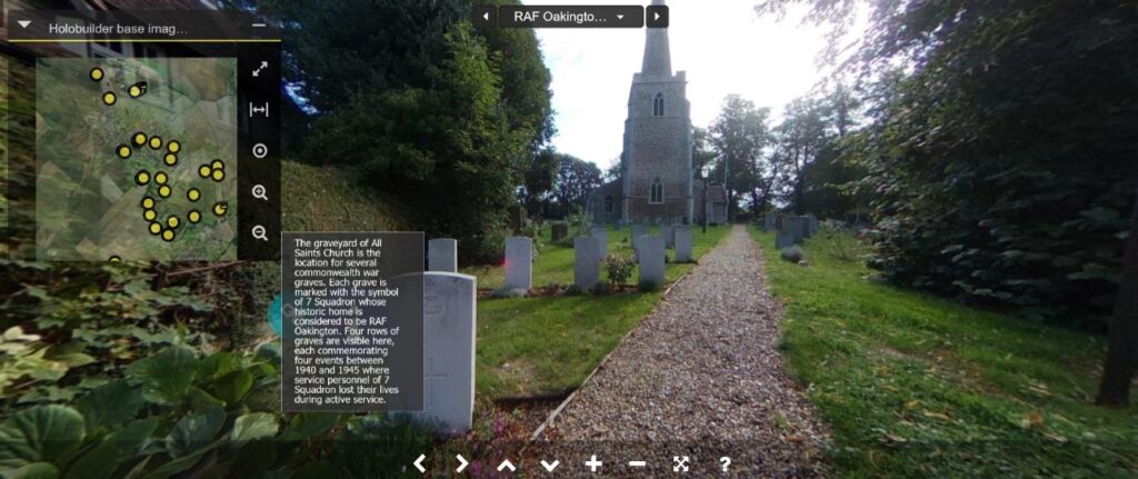
The use of 360 cameras and Holobuilder can replace the written element of walkover surveys and improve accuracy by viewing sites holistically rather than through a series of isolated 2D images. This was used by Arcadis’s Heritage team on a large-scale town/housing development in Northstowe, to create an interactive story of the site’s history and archaeology. The interactive walkover was shared with stakeholders during consultation and resulted in the inclusion of an interactive heritage trail as part of the future development, to allow the future communities of Northstowe to remain connected with the past.
Remote sensing and the use of Unmanned Aerial Vehicles (UAVs), are becoming increasingly popular surveying tools, particularly for pre-classification of Phase 1 habitat mapping. Sensors from satellites, aircraft and UAVs can produce datasets varying from typical photography through to elevation datasets such as LIDAR and vegetation indices such as NDVI. Such data makes it possible to characterise habitats according to Phase 1 Habitat Survey classes, and in some cases identify the boundaries of homogenous vegetation stands from just an image. The data provides an initial classification prior to any on-site survey work that it can be ‘ground-truthed’ on-site or used to support early-stage feasibility or strategic assessments.
Combining the aerial data with Collector Apps or mobile mapping systems reduces the ‘head-down’ cartographic tasks typically required when visiting sites. This, and the reduction in the extent of site visits, allows surveyors to focus on the key site constraints and any potential health and safety hazards. WSP were able to use remote sensing and Ordnance Survey datasets when preparing the biodiversity baseline for all of Transport for London’s estates. In doing so, WSP were able obtain data for areas that would have been unsafe to access in person.
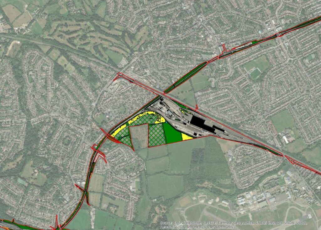
Additionally, remote sensing and UAVs allow large areas of land to be covered relatively quickly compared to using traditional methods, with cost savings passed on to the client. This was also demonstrated by Arcadis on the A66 Northern Trans-Pennine project, where undertaking UAV Phase 1 habitat surveys realised 34% cost savings and allowed the project to overcome both time and access constraints.
UAV collected data has many other applications. This has included collecting LIDAR data for identifying unknown archaeological remains, building 3D models for detailed viewshed analysis or providing detailed imagery for visualisations.
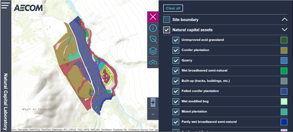
Utilising nearly every tool cited in this article, AECOM, in partnership with The Lifescape Project, have been developing the ‘Natural Capital Laboratory’, which has implemented several innovative approaches over the past year (UAVs, AI (artificial intelligence), robotics, and remote sensing) to support the ‘rewilding’ of 100 acres of land in Scotland. Using Phase 1 Habitat survey data as the basis for machine learning, AECOM have developed an AI which is able to classify habitats using land satellite and UAV imagery (with results periodically verified by ecologists). To enable the application of AI across other projects and a greater range of geographies, AECOM will need to collect and upload a greater range of Phase 1 habitat data. Alongside the AI, AECOM have created a virtual reality model (or digital twin) of the site which they aim to develop into accurate and interactive virtual map of the site.
As
our industry evolves, digital methods of data collection and analysis are
likely to become more integral to the projects we work on. Demonstrated through
the case studies in this article, such practices are overcoming challenges,
such as health and safety and access, and realising cost and time savings. As
well as resolving existing problems, digital methods are creating new
opportunities to expand the capacity and improve the accuracy of data
collection.